By The Discover the Odds Team
Updated August 24, 2023
First, a trickle. Then, a flood of awareness swept the world, the U.S., the headlines, online chatter, cell phone text messages and notifications: that unusual as it would be in late August 2023, closing out one of the warmest summers on record globally, a storm called Hurricane Hilary was barrelling straight towards southern California, bringing with it the risk of “catastrophic and life-threatening flooding.”
Contents
- 1 The preparation, the storm, recovery and huge sighs of relief
- 2 Tropical Storm Hilary brings “widespread improvements” in drought areas
- 3 Looking back: The formation and rise of Hurricane Hilary
- 4 What “first-ever” warning was issued?
- 5 What coordinated preparatory actions were prompted by the storm?
- 6 Why did the storm’s status change from hurricane to tropical Storm?
- 7 Did the storm’s change in status from a hurricane to a tropical storm mean that the risk of deadly “catastrophic” rainfall brought by Tropical Storm Hilary was averted?
- 8 How can Californians stay connected and get assistance when needed?
- 9 What’s the best way to stay informed about emergency situations, including the Tropical Storm Hilary?
- 10 What steps should be taken to prepare for high winds and ocean surges?
- 11 What precautions should be taken during a high wind event?
- 12 Why is it recommended to avoid the ocean during this time?
- 13 How should travel plans be adjusted during the storm’s peak?
- 14 What steps can be taken to be prepared for potential power outages?
- 15 What guidance should individuals follow from local authorities?
- 16 Share this
The preparation, the storm, recovery and huge sighs of relief
While it cannot be overstated that some Southern California residents caught in the path of Tropical Storm Hilary are, one week after its intensification, faced a challenging path to recovery from flooding and damaging that would have seemed unimaginable just two weeks earlier, millions more in the region seem to have escaped the worst. Observation suggests that an effective system of timely warnings as well as swift and decisive coordinated preparation efforts put into place leading up to the arrival of Tropical Storm Hilary in the most populous region of the West blunted it possible impact, including fatalities.
Tropical Storm Hilary brings “widespread improvements” in drought areas
One week out, data also reveals another odds-defying development: the “heavy rainfall accumulations” and “remnant moisture” associated with Tropical Story Hilary brought with it improvements in California and Nevada’s drought-affected areas, helping to eliminate areas of drought according to a map released by the U.S. Drought Monitor on August 24.
Looking back: The formation and rise of Hurricane Hilary
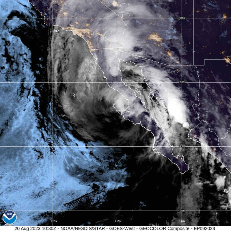
Wednesday, August 16, Hilary formed as a tropical storm off the coast of Manzanillo, Mexico. Between Thursday, August 17 and Friday, August 18, over a 24-hour period, the system exhibited an increase in maximum sustained winds of more than 30 knots (35 mph). Hilary had rapidly intensified from a tropical storm to a Category 4 major hurricane, all as it made its way off the west coast of Mexico and onward north with Southern California squarely in its trajectory ahead.
What “first-ever” warning was issued?
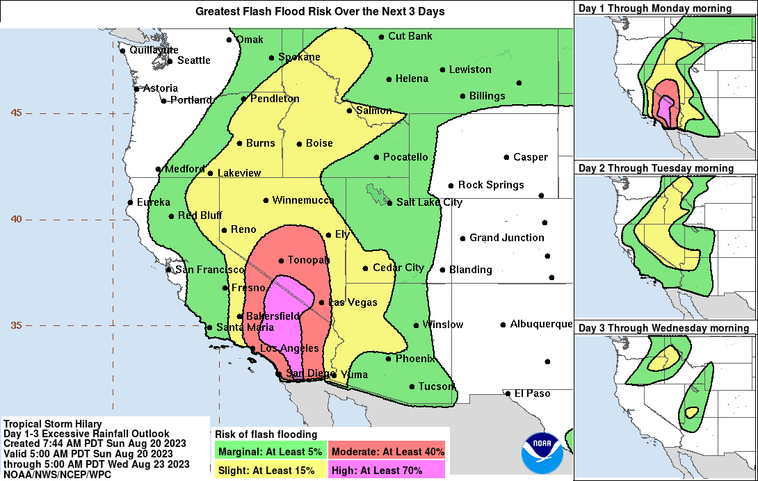
In the midst of these rapid developments in weather conditions, on August 18, 2023 the National Hurricane Center (NHC) issued its first ever tropical storm watch for California. Additionally, citing an anticipated onslaught of heavy rainfall, described as “more than a year’s worth of rain” in some areas, flood watches were issued for people across the states of Arizona, California, Nevada, and Utah, and the Weather Prediction Center (WPC) designated the region as under a high risk threat for flash flooding.
What coordinated preparatory actions were prompted by the storm?
Preparatory measures ahead of the approaching storm Hilary spanned from national to local levels, with a range of organizations taking action to ensure safety and minimize potential damage. At the highest level, the United States Navy orchestrated the movement of carriers and ships, notably the USS Theodore Roosevelt, away from the storm’s projected path. Aircraft were also secured in hangars to prevent their exposure to the upcoming weather.
On the federal front, President Joe Biden’s directive prompted the Federal Emergency Management Agency (FEMA) to deploy staff and personnel to southern California. President Biden, signaled concern for the well-being of residents, and advised those in the storm’s trajectory to adopt precautionary measures.
At a state level, Nevada’s governor, Joe Lombardo, displayed swift responsiveness by deploying 100 National Guard troops to aid in addressing the severe weather impact on southern Nevada. Meanwhile, California’s governor, Gavin Newsom, declared a state of emergency for Southern California.
Within California, proactive initiatives were taken by the California National Guard as they strategically positioned themselves across various locations in southern California as of August 19, enhancing the state’s readiness for Hilary’s arrival.
Looking beyond governmental efforts, various cultural and recreational events were affected. The ongoing strikes organized by the Writers Guild of America and SAG-AFTRA were suspended for Monday in Los Angeles, reflecting a concerted effort to prioritize safety. Similarly, Major League Baseball made adjustments to its schedule, postponing games for the San Diego Padres, Los Angeles Dodgers, and Los Angeles Angels.
The sports community extended their cautious approach as Major League Soccer rescheduled home games for the LA Galaxy and Los Angeles FC. In contrast, the National Football League chose not to cancel a Los Angeles Chargers preseason game at SoFi Stadium.
In the cultural sphere, the impact was evident as a concert slated at the Hollywood Bowl was rescheduled. Additionally, the Los Angeles County Department of Parks and Recreation took a preventative stance by closing all its areas. The iconic Disneyland and Disney California Adventure parks shuttered their doors early, while Legoland California, SeaWorld San Diego, and San Diego Zoo also remained closed on August 20.
The educational sector too made accommodations, with California State University, Los Angeles opting to cancel classes on August 21, demonstrating an effort to safeguard the well-being of students and faculty.
Why did the storm’s status change from hurricane to tropical Storm?
Climatology ratings for classifying tropical cyclones define a tropical storm as being characterized by maximum sustained winds of 39 to 73 mph (34 to 63 knots). A hurricane is defined as a tropical cyclone with maximum sustained winds of 74 mph (64 knots) or higher. According to the Saffir-Simpson Hurricane Wind Scale, which categorizes hurricanes on a scale of 1 – 5 by lowest to highest wind speeds, the range for a Category 1 hurricane is defined by sustained winds of 74-95 mph. In short, when Hillary’s maximum sustained wind speed dropped to below the level categorized as a hurricane, as was expected, it was reclassified as a tropical storm.
Did the storm’s change in status from a hurricane to a tropical storm mean that the risk of deadly “catastrophic” rainfall brought by Tropical Storm Hilary was averted?
The risks previously described remain and should continue to be taken as seriously. Sunday morning, August 20, the NOAA disseminated a fresh advisory about Tropical Storm Hillary, calling for the completion of preparation for flooding across the Southwestern United States, as the agency warned that the “potentially historic amount of rainfall is expected to cause life-threatening to locally catastrophic flash, urban, and arroyo flooding, including landslides, mudslides, and debris flows through early Monday morning.”
Historical precedence is also instructive, revealing that such a change in status from hurricane to tropical storm by the time a storm makes landfall does not alleviate the potential for deadly harm it can bring or preclude its consequential impact. By the September 1939 arrival onshore of El Cordonazo, its status had similarly changed from hurricane to tropical storm. To so many, the odds of massive flooding might have understandably seemed very slim. Yet, once the storm arrived, the only tropical storm occurring in the entire state in all of the twentieth century, it brought with it shockingly torrential rainfall over a 24-hour period, resulting in large-scale flooding, millions in property damage and nearly 100 deaths. A response also followed, transforming the weather forecasting landscape in a direction that would have a favorable impact on future preparedness in the region: the weather bureau moved to establish a forecast office for southern California, which began operations months later in February of 1940.
Before and throughout Sunday, August 20, preparations were urged of residents to safely meet the hazardous odds brought by the approaching storm Hilary in a region unaccustomed to tropical storms and the risks they carry.
How can Californians stay connected and get assistance when needed?
Californians are advised to dial 3-1-1 for help or to ask questions. In critical emergencies, you should call 911.
What’s the best way to stay informed about emergency situations, including the Tropical Storm Hilary?
To stay informed, it’s recommended to sign up for emergency alerts, including warnings and evacuation notices. You can do this by visiting CalAlerts.org and registering to receive alerts from your county officials.
What steps should be taken to prepare for high winds and ocean surges?
Before a high wind event occurs, it’s important to take certain measures. This involves removing dead trees and overhanging branches near structures, securing loose roofing material, bringing in unsecured objects from patios and balconies, ensuring outdoor objects that could be blown away are secured, shuttering windows securely, and bracing outside doors.
What precautions should be taken during a high wind event?
During a high wind event, it’s advisable to seek cover near a building or under shelter, stay away from windows, avoid roadways and train tracks, steer clear of elevated areas like roofs, and be vigilant for flying debris.
Why is it recommended to avoid the ocean during this time?
The National Weather Service issued a high surf advisory due to Hurricane Hilary’s anticipated strong breaking waves, shore breaks, and potent longshore and rip currents. As a result, beachgoers are strongly advised to stay out of the ocean, given the extreme danger.
How should travel plans be adjusted during the storm’s peak?
It’s suggested to avoid non-essential travel on Sunday and Monday when the storm is expected to be at its peak. For those who must drive, downloading the QuickMap app or visiting QuickMap (ca.gov) can provide real-time updates on road conditions, traffic, closures, and more. It’s essential to refrain from walking, swimming, or driving through flood waters, as even small amounts of moving water can pose serious risks.
What steps can be taken to be prepared for potential power outages?
Being ready for power outages involves taking inventory of electricity-dependent items, ensuring devices are charged, and planning for alternative power sources like portable chargers or power banks. Having flashlights for every household member and making provisions for the potential of water shortages is also recommended.
It’s crucial to always heed the guidance of local authorities. This includes adhering to evacuation orders, road closures, and other official notices to ensure safety during the storm and its aftermath.